Unit Objectives
- identify and locate key geographical features of Yosemite National Park on maps, including major landmarks, rivers, and terrain and gain an understanding of the key events and historical context surrounding the establishment of Yosemite National Park.
- analyze primary source materials, such as letters, documents, and photographs, to extract information about the early history of Yosemite and the people involved.
- critically evaluate primary source materials, considering the reliability, bias, and perspective of different sources.
- explore diverse cultural perspectives related to the establishment of Yosemite National Park considering the viewpoints of native Americans, early explorers and settlers, journalists, artists, business people, and conservationists.
- use GIS tools to analyze spatial data related to Yosemite, exploring how geographic information systems can enhance historical research and understanding.
- effectively communicate their understanding of the early history of Yosemite National Park through written and oral presentations, incorporating information from primary sources.
Students will:
Related National Standards
GIS Activities

GIS investigations are part of many of the activities in this unit. These investigations make use of ArcGIS Online, an internet software that runs on most browsers. If you do not have an ArcGIS account and would like to have one you can sign up for a free personal account here.
The data and shapefiles in the various map layers are from a variety of sources:
California Relief Map, California Counties, California Rivers & Lakes
Information Related to Early Yosemite Trails
Lafayette H. Bunnell. "Map of the Yo-Semite Valley." in Discovery of the Yosemite. New York: F H Revell Company, 1892.
Linda W. Greene. "Early Trails." and "Historical Base Map of Roads and Trails, Yosemite National Park." in Yosemite: The Park and Its Resources. Yosemite National Park, California: National Park Service, 1987.
Thomas Frederick Howard, Sierra Crossing: First Roads to California, Berkeley: University of California Press, 1998.
Zenas Leonard. Narrative of the Adventures of Zenas Leonard. Clearfield, Pennsylvania: D. W. Moore, 1839.
Tredwell Moore. "Reports from Lt. Tredwell Moore to the Pacific Division on the Mariposa Indian War of 1852." as found in Thomas C. Fletcher, Paiute, Prospector, Pioneer: The Bodie-Mono Lake Area in the Nineteenth Century, (Lee Vining, California: Artemisia Press, 1987.
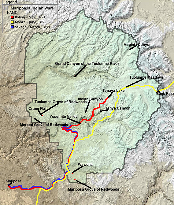
Carl P Russell. "The Geography of the Mariposa Indian War." in Yosemite Nature Notes. XXX(3,4,6,7), 1951.
Carl P Russell. "Sketch Map of the Yosemite Region." One Hundred Years in Yosemite. Berkeley, California: University of California Press, 1932
U.S. Geological Survey, "Yosemite (1911) and Mt. Lyell (1901) Quadrangle 30-minute topographic maps", available at the Historic Topographic Maps of California, University of California, Berkeley Library.
Yosemite Boundary File & Yosemite Lakes Plants, and Dams
“Boundary of Yosemite National Park, California,” available from the National Park Service Geography and Mapping Technologies, Geographic Information Systems web page.
Yosemite Area
clipped from “30m Color Hillshade of California,” available from California State Geoportal
Yosemite Topographic Map
Topographic map of Yosemite National Park, California / from Geological Survey maps surveyed between 1893 and 1909,” available from the American Geographical Society Library at the University of Wisconsin-Milwaukee Libraries.
Additional resources
Those interested in learning more will find that the Internet offers a variety of interesting materials.
Yosemite National Park
Visit the Yosemite National Park Web pages to learn more about the history of this geological wonder. Details on the history and geology of the park, photo galleries, educational resources, and much more are included on the site. The Yosemite Web is a tremendous resource of both primary and primary resources about Yosemite. The web site of the Yosemite Conservancy is also a valuable resource.
The National Park Idea
The United States created the world's first national park (Yellowstone), as well as the first national park system. The National Parks: Shaping the System explores the evolution of the "national park idea."
U.S. Geological Survey
The Geologic Story of Yosemite Valley is an essay from the U.S. Geological survey outlining the geologic history of Yosemite Valley. It touching on the roles of erosion and glacial action in carving the granite features of the park.
Library of Congress: American Memory Collection
Search the American Memory Collection for resources on Yosemite National Park.
For Further Reading
Students and educators wishing to learn more about Yosemite may want to read the following: Alfred Runte, Yosemite: The Embattled Wilderness (University of Nebraska Press, 1990). Carl Parcher Russell, One Hundred Years in Yosemite; The Story of a Great Park and Its Friends 2d. ed. (Berkeley: University of California Press, 1947).