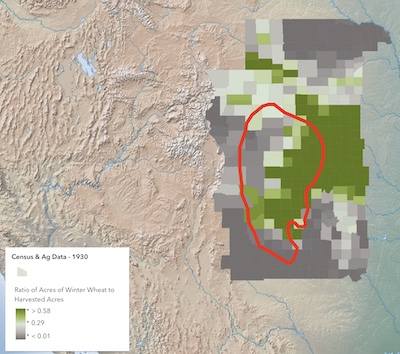
Winter wheat was the primary crop on the Great Plains in the 1930s. The promise of riches from the sale of this crop in the East had brought farmers to the plains in ever increasing numbers during the last decades of the 19th and the first decades of the 20th centuries. Along with increasing demand for the crop, particularly during and after World War I, and the introduction of mechanized farming, vast stretches of the plains were plowed under to wheat and other crops.
How intensive was the farming of winter wheat in the Dust Bowl region? Census data from 1930 and 1940 can help provide a picture; a picture that can be used to examine changes over the decade of the 1930s. Open two copies of the Dust Bowl: Population & Agriculture map and display the Census & Agriculture - 1930 layer on one and the Census & Agriculture - 1940 layer on the other along with the Area of Worst Dust Storms - 1935 layer and the same basemap for each. Turn any other open layers off. Click on any county and the pop-up will reveal the nature of the data you have about each county. Note that the available data is somewhat different for the two decades.
The 1930 layer shows the number of bushels of winter wheat harvested that year compared to the number of harvested acres in each county including wheat and other crops. That is, it shows the amount of wheat harvested per acre of agricultural land. The data is colored dark gray to dark green from least to greatest percentage.
• Select to change Styles (
) and then to Style options.
• You can change the symbol style and shading pattern.
• Note that the data ranges from 0 and roughly 0.90 and that you can move the individual sliders up and down.
Go to the other map and change the symbols on the 1940 layer to show the same comparison using the same color classification and slider settings making for an easy comparison. You can easily see the rate at which the harvested land is used for wheat.
Notice that at the bottom of the pop-up for each county there is a column graph showing the percentage of acres of winter wheat harvested compared to all harvested acres in the county including wheat and other crops. The graph has also been normalized - you can see the rate at which the harvested land is used for wheat.
1) In relation to the worst 1935 dust storms, where was the most winter wheat harvested in 1930? in 1940?
2) Look at counties within the area of the worst dust storms in 1935 on both maps. Describe the general pattern of change in winter wheat production 1930 to 1940.
3) Sometimes what is most interesting when looking at a pattern are the exceptions to the general rule. Identify an exception to the general pattern of change you noted in the worst dust region and describe the ways in which the county is different from those surrounding it.
4) Did the number and size of farms on the Great Plains change over the decade of the 1930s? Prepare side-by-side maps using to compare both the number of Dust Bowl farms and their average size for 1930 and 1940.
a) What geographic pattern do you notice in the maps showing the average size of farms? How does this pattern compare with that in the maps showing the number of farms in each county?
b) How did the number and size of farms in the Great Plains change over the Dust Bowl decade?
c) Discuss any general conclusions that you draw in comparing your maps. Make sure that you identify any exceptions to the generalizations you discuss.
5) Did the practice of tenant farming in the Great Plains change over the decade of the 1930s?
a) Examine the data categories available to you in the census files for 1930 and 1940. List the specific categories for each year that might lend themselves to addressing the question.
b) Prepare side-by-side maps using the data you have identified.
c) Use your maps and write a short analysis of the information presented.
6) Write your own question about farming in the Dust Bowl region of the Great Plains during the decade of the 1930s based on the census data available to you. Prepare appropriate maps and tables and write a short summary of your conclusions using these Evaluation Guidelines.
