Unit Objectives
- Develop a picture of Cherokee culture in the late 1700s and early 1800s by analyzing primary accounts.
- Understand the arguments for and against removing the Cherokee from their land in the southeast.
- Gain experience in evaluating the credibility of primary and primary accounts of historical events.
- Use GIS software to explore the 1835 federal census of the Cherokee and use the census to evaluate conclusions about the Cherokee and about the "Trail of Tears" experience.
Related National Standards
GIS Activities

GIS investigations are part of many of the activities in this unit. These investigations make use of ArcGIS Online, an internet software that runs on most browsers. If you do not have an an ArcGIS account and would like to have one you can sign up for a free personal account here.
The data and shapefiles in the various map layers are from a variety of sources:
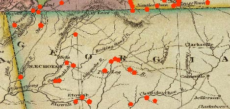
Melish Map - 1822
John Melish, United States of America, Philadelphia: 1822 as found at the David Rumsey Map Collection.
Missions
Mission locations from map in Theda Perdue and Michael D. Green, The Cherokee Removal: A Brief History with Documents, Boston: Bedford Books, 1995, p 22.
Georgia Gold Regions
Derived from "The Gold Deposits of Georgia," in David Williams, The Georgia Gold Rush, Columbia, South Carolina: University of South Carolina, 1993, p 93.
Census
Based on a 10% random sample from National Archives, Census Roll, 1835, of Cherokee Indians East of the Mississippi. NA#T496
Geographic locations in most cases are accurate only to the location of the river or creek identified in the census. Exact locations are not known.
United States - 1830
Minnesota Population Center. National Historical Geographic Information System: Version 2.0. Minneapolis, MN: University of Minnesota 2011.
Additional Resources
Grant Foreman, Indian Removal, University of Oklahoma Press, 1974.
Theda Perdue and Michael D. Green, The Cherokee Removal: A Brief History with Documents, Boston: Bedford Books, 1995.